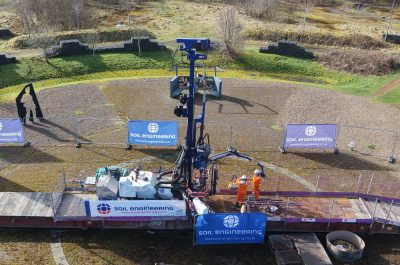
Soil Engineering Take Office and Laboratory Data Management to a Whole New Level

After an extended period of development and testing by SEGL Data Manager, Ian Linton, SEGL have commenced the process of upgrading our geotechnical database system to the very latest and much enhanced software Holebase SI. The new system has already been installed and is in use at the Coatbridge office. Work is currently underway at Leeds and the Camberley office.

HolebaseSI takes the management and presentation of ground investigation data to an entirely new level. Spreadsheet style views allow the user to easily view all data and to verify data consistency and completeness whilst the mapping functions allow borehole locations to be displayed in the real world and for the easy production of cross sections to assist in understanding the ground conditions and describing them in a ground investigation report. Links are also provided to external data such as the BGS 1:50,000 Geology maps and BGS borehole data.

In the Leeds geotechnical laboratory we have recently started to use KeyLab 2, another hugely enhanced software product compared to the original KeyLab which we used for many years. Already in use for many classification and rock tests, development work on KeyLab 2 is currently focussed on more sophisticated tests where our high standards of calibration have required modifications to the programme. It is anticipated that these tests will progressively be transferred into the new system over the coming months.

Taken together, KeyLab 2 and HolebaseSI with its extensions to Excel and AutoCAD Civils, combined with field data capture using KeyLogbook, will allow SEGL to seamlessly take source data through to final report and AGS Version 4 digital data more efficiently than has ever previously been possible.

1:00 AM Jan 1st

Sign up

  • This field is for validation purposes and should be left unchanged.